Notices tagged with dfwwx
-
From NWSFortWorth https://twitter.com/NWSFortWorth on Twitter: For DFW Airport, July 11 is the 38th consecutive day without measurable precipitation. This is the longest streak since a 40-day rainless spell in 2019. https://www.weather.gov/fwd/dnorain #dfwwx #txwx #drought
-
From NWSFortWorth https://twitter.com/NWSFortWorth on Twitter: A cold front will make its way into the region early Monday morning. No chance of precipitation, just blustery winds and cooler temperatures this time around. Monday afternoon holds an elevated fire danger threat for areas west of I-35. #dfwwx #ctxwx #txwx https://twitter.com/NWSFortWorth/status/1315396760378900480/photo/1 https://chirp.cooleysekula.net/attachment/68250
-
From NWSFortWorth https://twitter.com/NWSFortWorth on Twitter: 6:55 pm, wind gust of 53 mph at Addison airport. Storms continuing to develop south through Dallas county where strongest winds are expected to continue. Severe thunderstorm warning in effect for Dallas county through 7:45 pm. #dfwwx
-
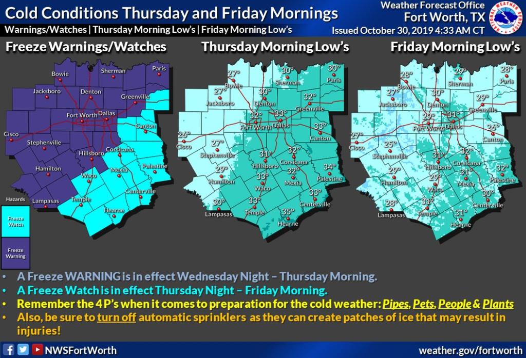
From NWSFortWorth https://twitter.com/NWSFortWorth on Twitter: A strong cold front will bring the first widespread freeze to the area tonight and tomorrow night. Please take precautions now and remember your 4 P's: Pets, People, Plants, Pipes. #txwx #dfwwx #ctxwx #texomawx https://twitter.com/NWSFortWorth/status/1189502205189087234/photo/1 https://chirp.cooleysekula.net/attachment/62059
-
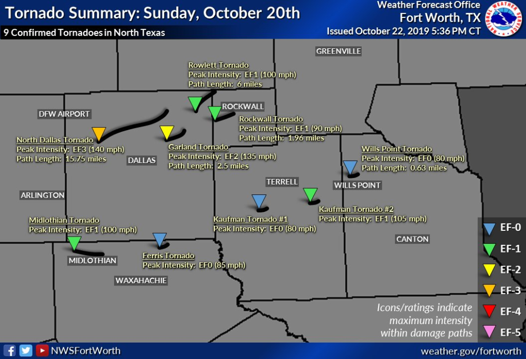
From NWSFortWorth https://twitter.com/NWSFortWorth on Twitter: 6:25 PM - 2 additional brief tornadoes were confirmed in Kaufman County, bringing the event total to 9 in North Texas. #dfwwx https://twitter.com/NWSFortWorth/status/1186785620208676864/photo/1 https://chirp.cooleysekula.net/attachment/61996
-
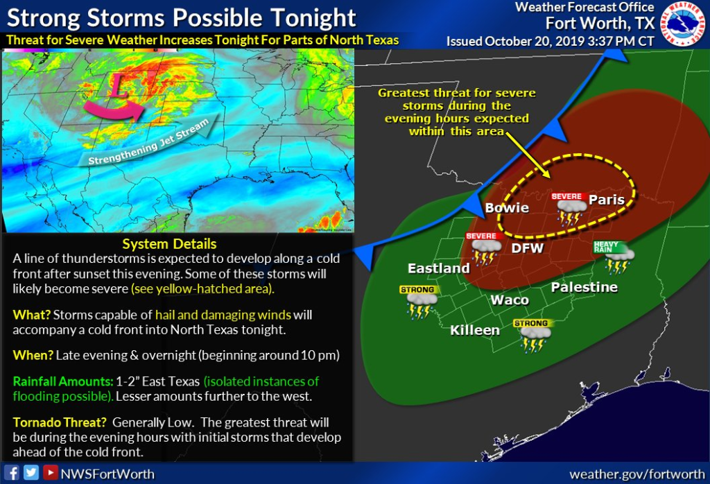
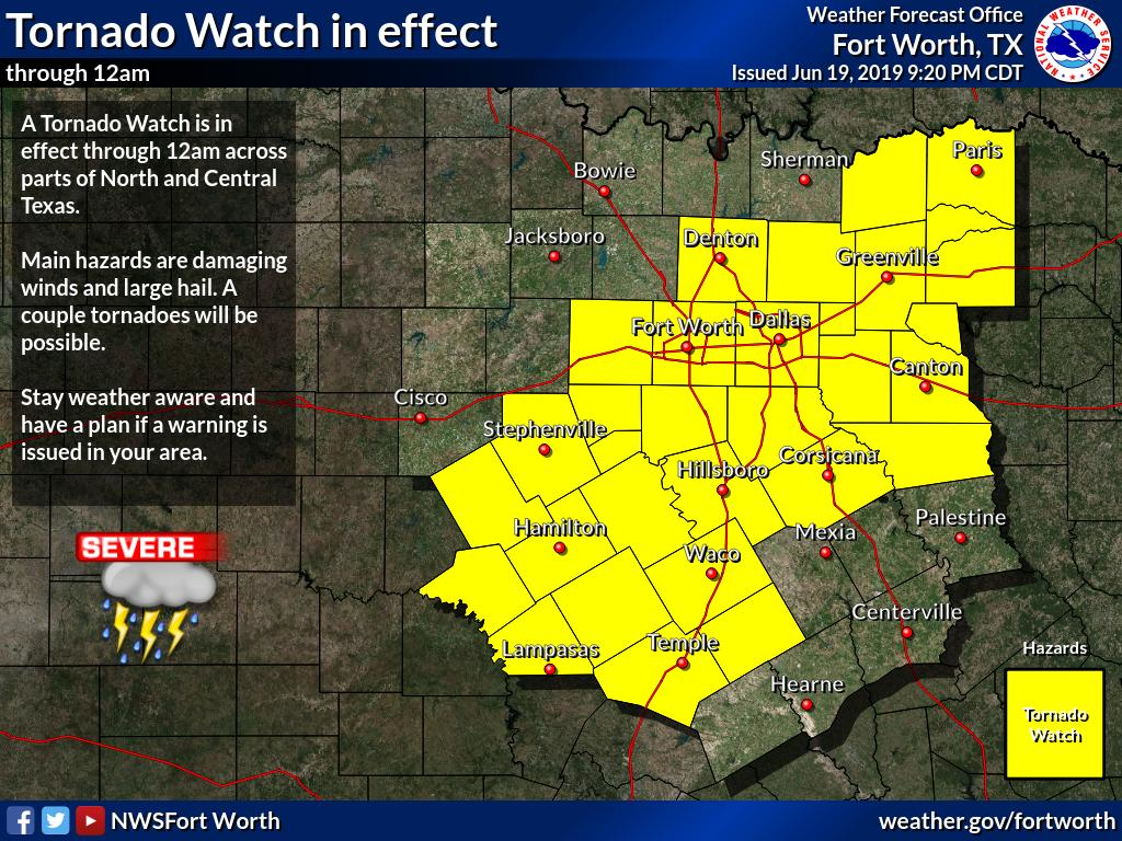
From NWSFortWorth https://twitter.com/NWSFortWorth on Twitter: ICYMI: A Tornado Watch is in effect through 2 AM for parts of the region. Main threats: Damaging winds, large hail & a few tornadoes possible. Pay close attention & be ready to take action if a warning is issued for your area. #dfwwx #ctxwx #txwx #texomawx https://twitter.com/NWSFortWorth/status/1186078308821164032/photo/1 https://chirp.cooleysekula.net/attachment/61975
-
From NWSFortWorth https://twitter.com/NWSFortWorth on Twitter: Afternoon Update - Slight adjustments made to the timing of the arrival of storms later this evening. Before you head to bed tonight make sure you have a few ways to get weather and warning information overnight. #txwx #ctxwx #dfwwx https://twitter.com/NWSFortWorth/status/1186042180407717888/photo/1 https://chirp.cooleysekula.net/attachment/61967
-
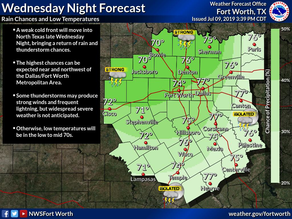
From NWSFortWorth https://twitter.com/NWSFortWorth on Twitter: Rain and thunderstorm chances will return Wednesday Night as a weak cold front moves into North Texas. #txwx #dfwwx #ctxwx https://twitter.com/NWSFortWorth/status/1148694738033401861/photo/1 https://chirp.cooleysekula.net/attachment/59282
-
From FWOEM https://twitter.com/FWOEM on Twitter: 8:40PM Weather Update: We're activated here in the Emergency Operations Center in Fort Worth with our partners monitoring the weather to our west/north west. We're closely watching the system with @NWSFortWorth & will issue updates as soon they're available. #dfwwx https://twitter.com/FWOEM/status/1142971008237879296/photo/1 https://chirp.cooleysekula.net/attachment/58664
-
From NWSFortWorth https://twitter.com/NWSFortWorth on Twitter: A Tornado Watch is still in effect for many of our counties until midnight tonight. Be sure to have ways of receiving warnings and alerts. These storms will be capable of producing large hail and damaging winds. A tornado can't be ruled out. #dfwwx #txwx https://twitter.com/NWSFortWorth/status/1141533469039874048/photo/1 https://chirp.cooleysekula.net/attachment/58568
-
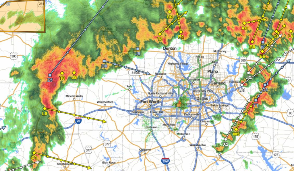
From jesus_jimz https://twitter.com/jesus_jimz on Twitter: Storms are popping up again. Collin County is under a severe t'storm warning until 10:15. Hail and wind gusts up to 60 mph are possible. #txwx #dfwwx https://www.dallasnews.com/news/weather/2019/06/19/severe-storms-dallas-fort-worth-wednesday-evening-could-produce-large-hail-damaging-winds https://twitter.com/jesus_jimz/status/1141531628776361984/photo/1 https://chirp.cooleysekula.net/attachment/58563
-
From Twitter https://twitter.com/drsekula: RT @NWSFortWorth: 2 pm: DFW has broken the record high today of 86F set in 1933. Current temperature 87F, and may still rise a degree or more. #dfwwx
-
From Twitter https://twitter.com/drsekula: RT @NWSFortWorth: DFW has hit 80 degrees for the 11th time this winter, setting a new #record for most 80s in a winter season. #dfwwx #txwx
-
From Twitter https://twitter.com/drsekula:
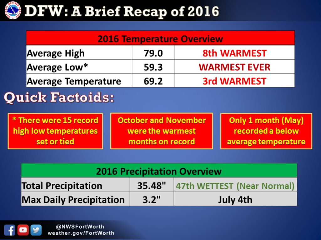
RT @NWSFortWorth: 3rd warmest year at DFW and above normal at Waco. Here's a quick rundown of how 2016 stacked up! #dfwwx #ctxwx https://twitter.com/NWSFortWorth/status/816104740866195456/photo/1 https://chirp.cooleysekula.net/attachment/20252
-
From Twitter https://twitter.com/drsekula:
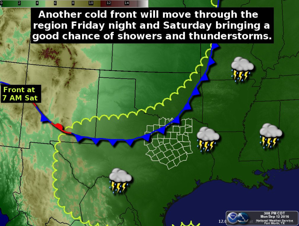
RT @NWSFortWorth: Mon 9/12/16 Front will bring a good chance of showers and thunderstorms Friday Night and Saturday #dfwwx #ctxwx https://t.co/4Xdt2hmttI https://chirp.cooleysekula.net/attachment/15371
-
From Twitter https://twitter.com/drsekula:
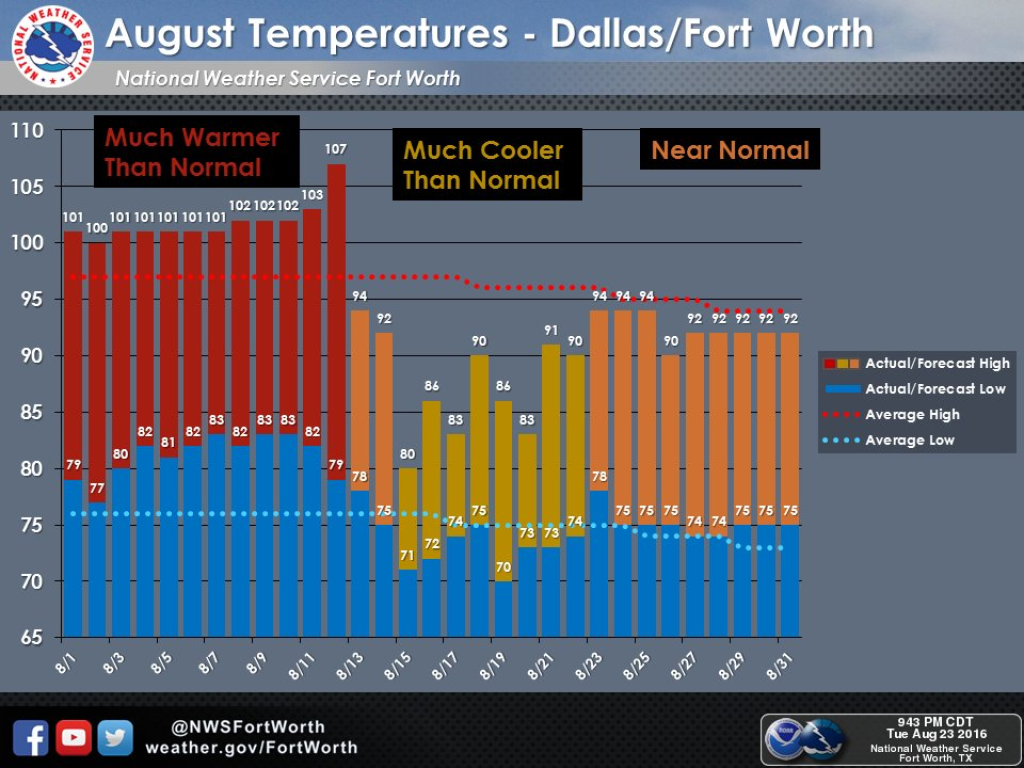
RT @NWSFortWorth: North Texas: August started out hot, then cooled down. Near normal temps expected for the rest of month. #dfwwx https://t.co/jhWZQUbSgZ https://chirp.cooleysekula.net/attachment/14668
-
From Twitter https://twitter.com/drsekula:
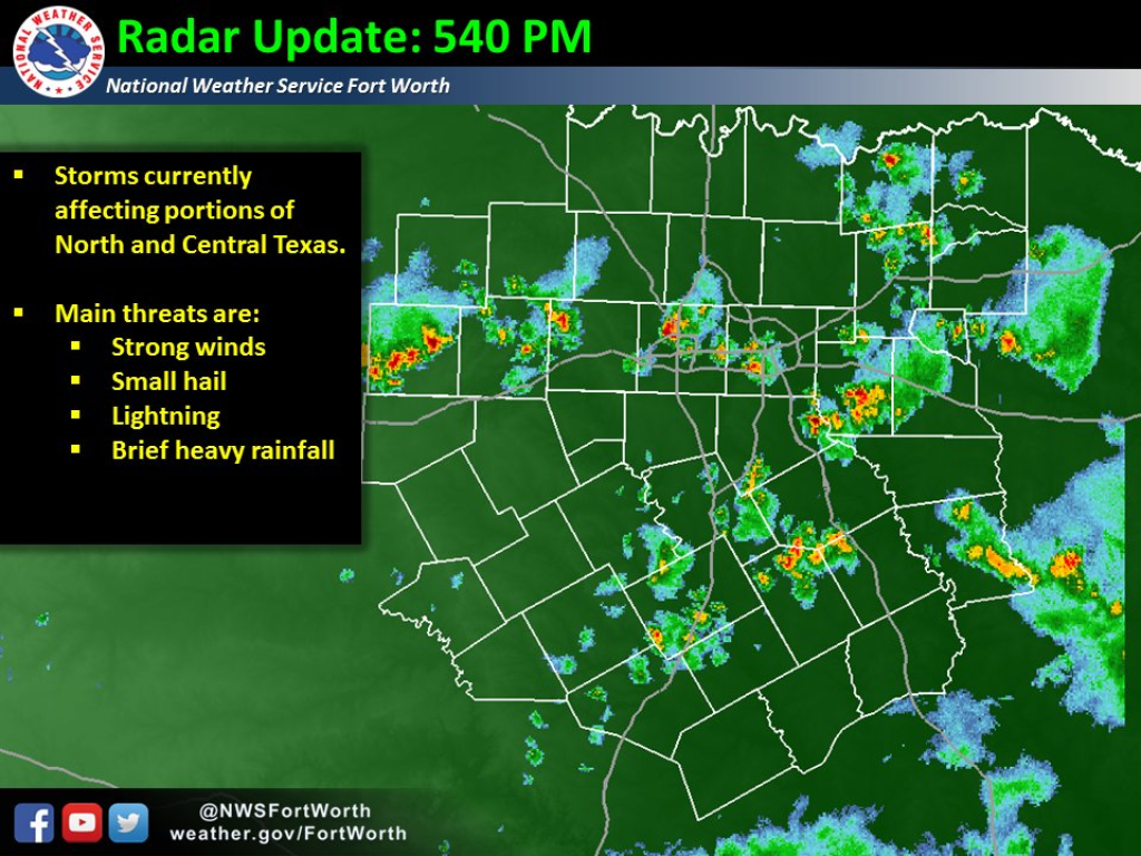
RT @NWSFortWorth: 540 PM: Storms continue over N and C TX. Main threats will be strong winds, heavy rain and lightning. #dfwwx #ctxwx https://t.co/41c1n3gSeM https://chirp.cooleysekula.net/attachment/13490
-
From Twitter https://twitter.com/drsekula:
RT @NWSFortWorth: DFW and Waco have both experienced their first freeze of this fall this morning! #dfwwx #ctxwx https://twitter.com/NWSFortWorth/status/668400663563497472/photo/1 https://chirp.cooleysekula.net/attachment/4314
-
From Twitter https://twitter.com/drsekula:
RT @NWSFortWorth: What is a squall line?? What do we watch out for? Here's some info! #txwx #dfwwx #ctxwx https://twitter.com/NWSFortWorth/status/666349908807385088/photo/1 https://chirp.cooleysekula.net/attachment/4182
-
From Twitter https://twitter.com/drsekula:
RT @DFWscanner: DFW is under an enhanced risk of severe weather overnight Monday into Tuesday. Big storms possible. #txwx #dfwwx https://twitter.com/DFWscanner/status/665975915118112768/photo/1 https://chirp.cooleysekula.net/attachment/4150

 Stephen Sekula