Notices tagged with txwx
-
From NWSFortWorth https://twitter.com/NWSFortWorth on Twitter: For DFW Airport, July 11 is the 38th consecutive day without measurable precipitation. This is the longest streak since a 40-day rainless spell in 2019. https://www.weather.gov/fwd/dnorain #dfwwx #txwx #drought
-
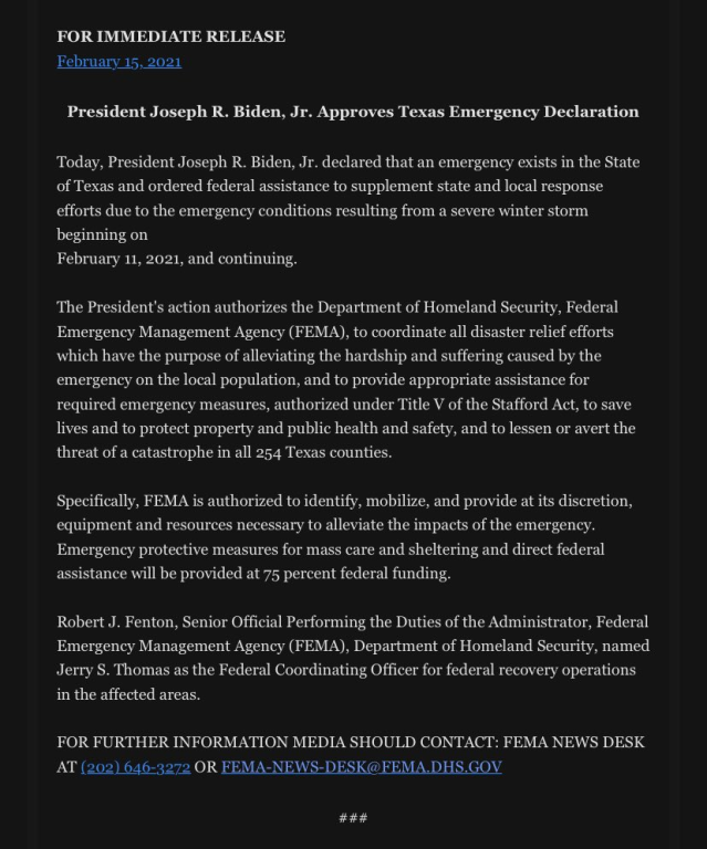
From JasonWhitely https://twitter.com/JasonWhitely on Twitter: #BREAKING: President Biden declares a disaster in Texas because of the winter storm. #txwx https://twitter.com/JasonWhitely/status/1361119645416255489/photo/1 https://chirp.cooleysekula.net/attachment/70776
-
From NWSFortWorth https://twitter.com/NWSFortWorth on Twitter: A cold front will make its way into the region early Monday morning. No chance of precipitation, just blustery winds and cooler temperatures this time around. Monday afternoon holds an elevated fire danger threat for areas west of I-35. #dfwwx #ctxwx #txwx https://twitter.com/NWSFortWorth/status/1315396760378900480/photo/1 https://chirp.cooleysekula.net/attachment/68250
-
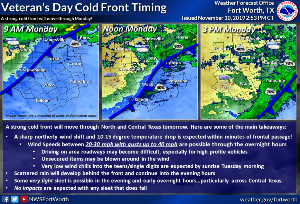
From NWSFortWorth https://twitter.com/NWSFortWorth on Twitter: A cold front will be moving through tomorrow. Expect cold, windy, and wet conditions with gusts up to 40 mph possible Monday afternoon and night. Some very light sleet is possible in the evening and early overnight hours, but no accumulation is expected. #txwx #ctxwx https://twitter.com/NWSFortWorth/status/1193645636714823680/photo/1 https://chirp.cooleysekula.net/attachment/62159
-
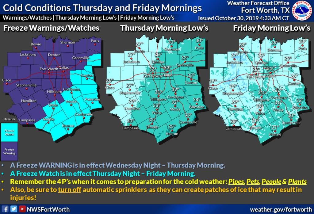
From NWSFortWorth https://twitter.com/NWSFortWorth on Twitter: A strong cold front will bring the first widespread freeze to the area tonight and tomorrow night. Please take precautions now and remember your 4 P's: Pets, People, Plants, Pipes. #txwx #dfwwx #ctxwx #texomawx https://twitter.com/NWSFortWorth/status/1189502205189087234/photo/1 https://chirp.cooleysekula.net/attachment/62059
-
From NWSFortWorth https://twitter.com/NWSFortWorth on Twitter: ICYMI: A Tornado Watch is in effect through 2 AM for parts of the region. Main threats: Damaging winds, large hail & a few tornadoes possible. Pay close attention & be ready to take action if a warning is issued for your area. #dfwwx #ctxwx #txwx #texomawx https://twitter.com/NWSFortWorth/status/1186078308821164032/photo/1 https://chirp.cooleysekula.net/attachment/61975
-
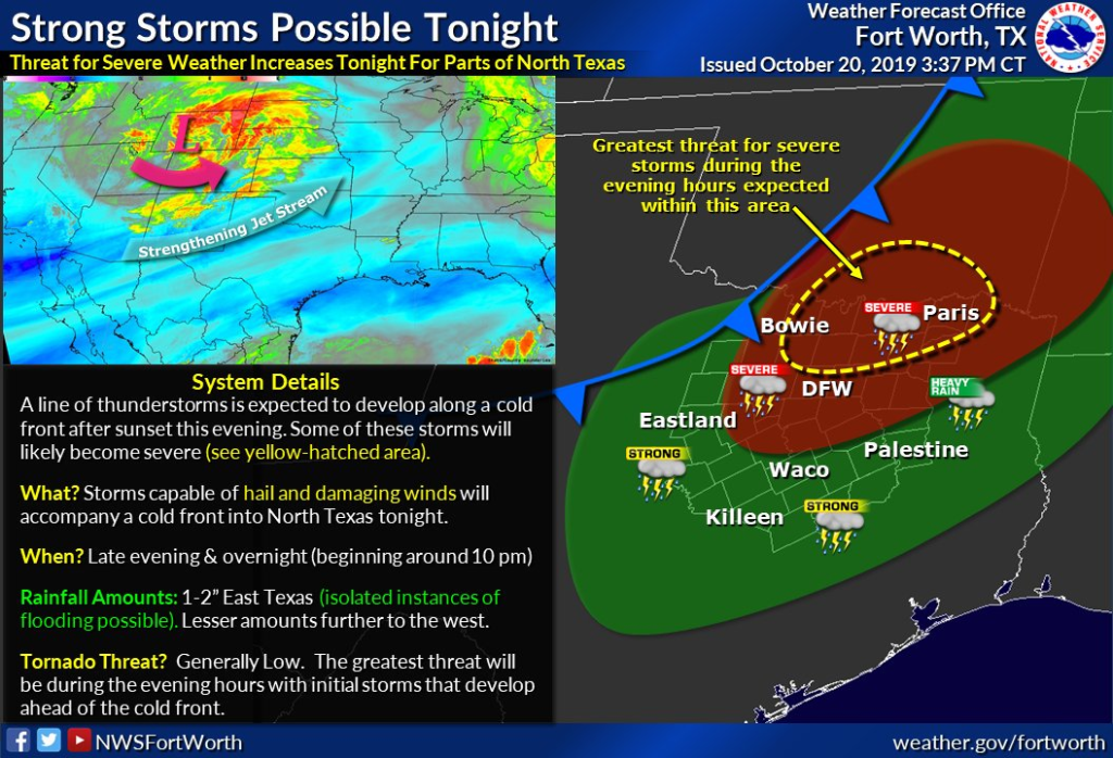
From NWSFortWorth https://twitter.com/NWSFortWorth on Twitter: Afternoon Update - Slight adjustments made to the timing of the arrival of storms later this evening. Before you head to bed tonight make sure you have a few ways to get weather and warning information overnight. #txwx #ctxwx #dfwwx https://twitter.com/NWSFortWorth/status/1186042180407717888/photo/1 https://chirp.cooleysekula.net/attachment/61967
-
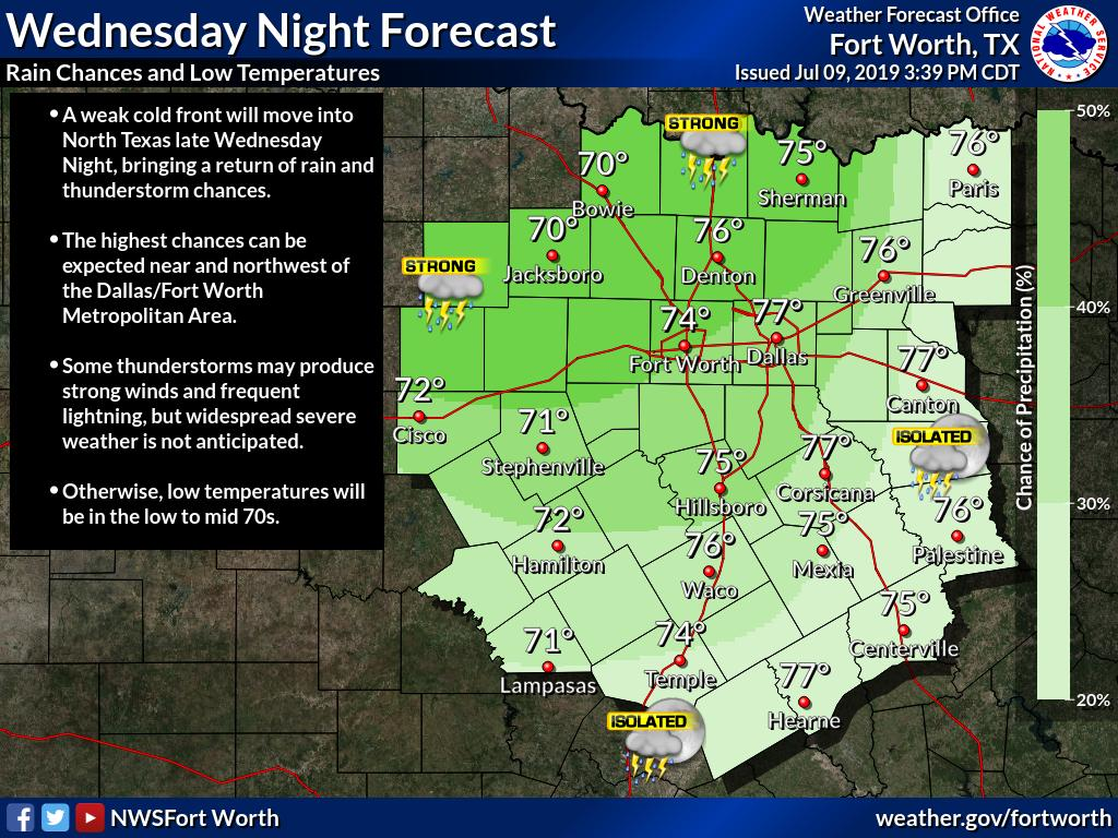
From NWSFortWorth https://twitter.com/NWSFortWorth on Twitter: Rain and thunderstorm chances will return Wednesday Night as a weak cold front moves into North Texas. #txwx #dfwwx #ctxwx https://twitter.com/NWSFortWorth/status/1148694738033401861/photo/1 https://chirp.cooleysekula.net/attachment/59282
-
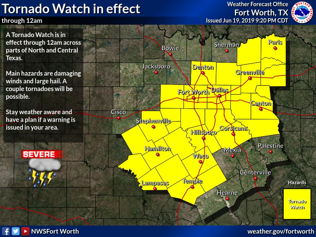
From NWSFortWorth https://twitter.com/NWSFortWorth on Twitter: A Tornado Watch is still in effect for many of our counties until midnight tonight. Be sure to have ways of receiving warnings and alerts. These storms will be capable of producing large hail and damaging winds. A tornado can't be ruled out. #dfwwx #txwx https://twitter.com/NWSFortWorth/status/1141533469039874048/photo/1 https://chirp.cooleysekula.net/attachment/58568
-
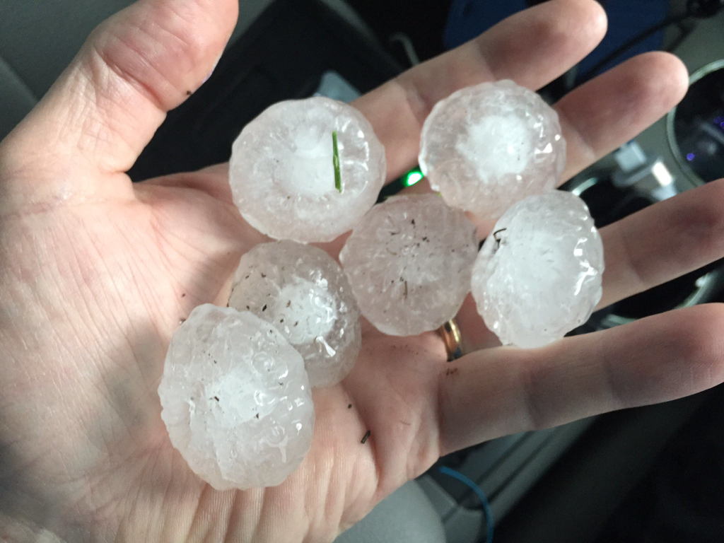
From jesus_jimz https://twitter.com/jesus_jimz on Twitter: Storms are popping up again. Collin County is under a severe t'storm warning until 10:15. Hail and wind gusts up to 60 mph are possible. #txwx #dfwwx https://www.dallasnews.com/news/weather/2019/06/19/severe-storms-dallas-fort-worth-wednesday-evening-could-produce-large-hail-damaging-winds https://twitter.com/jesus_jimz/status/1141531628776361984/photo/1 https://chirp.cooleysekula.net/attachment/58563
-
From Twitter https://twitter.com/: #TxWx #texas https://twitter.com/JesseWFAA/status/940055904669409280/photo/1 https://chirp.cooleysekula.net/attachment/45295
-
From Twitter https://twitter.com/drsekula:
RT @JasonWhitely: Quarter size hail stones east of Denton, Texas on Hwy 380. #wfaaweather #txwx https://twitter.com/JasonWhitely/status/846153979016990720/photo/1 https://chirp.cooleysekula.net/attachment/26466
-
From Twitter https://twitter.com/drsekula: RT @NWSFortWorth: DFW has hit 80 degrees for the 11th time this winter, setting a new #record for most 80s in a winter season. #dfwwx #txwx
-
From Twitter https://twitter.com/drsekula:
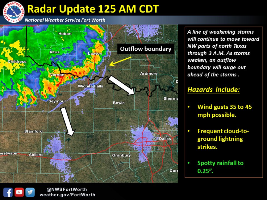
RT @NWSFortWorth: An outflow boundary will continue to surge ahead of a weakening line of storms. Gusty winds 35-45 mph psbl. #txwx https://twitter.com/NWSFortWorth/status/754201942138626048/photo/1 https://chirp.cooleysekula.net/attachment/12985
-
From Twitter https://twitter.com/drsekula:
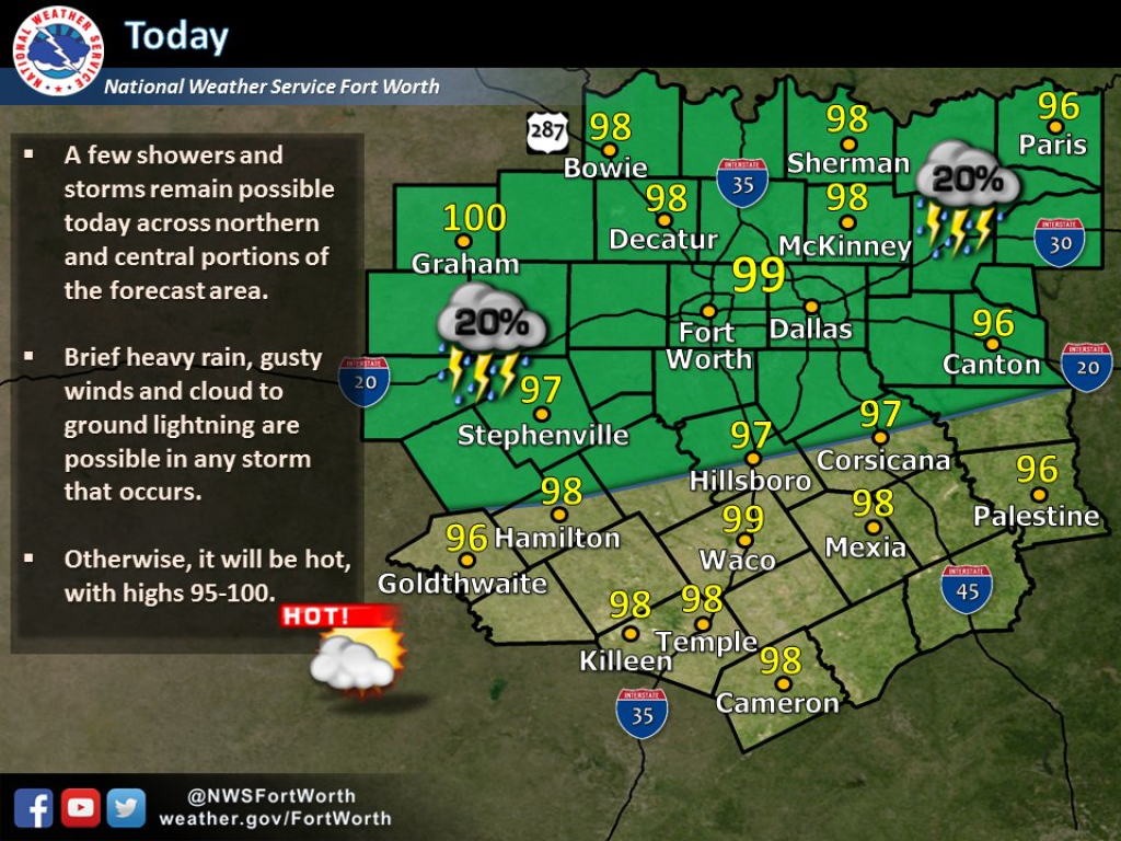
RT @NWSFortWorth: Slight chance of rain for the rest of the day, but for most of us a normal hot summer Saturday. #txwx https://twitter.com/NWSFortWorth/status/754291450200723459/photo/1 https://chirp.cooleysekula.net/attachment/12979
-
From Twitter https://twitter.com/drsekula:
RT @DFWscanner: The Metroplex is on the far western edge of a Flash Flood WATCH in anticipation of strong storms overnight. #txwx https://twitter.com/DFWscanner/status/666369325012389888/photo/1 https://chirp.cooleysekula.net/attachment/4184
-
From Twitter https://twitter.com/drsekula:
RT @NWSFortWorth: What is a squall line?? What do we watch out for? Here's some info! #txwx #dfwwx #ctxwx https://twitter.com/NWSFortWorth/status/666349908807385088/photo/1 https://chirp.cooleysekula.net/attachment/4182
-
From Twitter https://twitter.com/drsekula:
RT @DFWscanner: DFW is under an enhanced risk of severe weather overnight Monday into Tuesday. Big storms possible. #txwx #dfwwx https://twitter.com/DFWscanner/status/665975915118112768/photo/1 https://chirp.cooleysekula.net/attachment/4150
-
From Twitter https://twitter.com/drsekula:
RT @DFWscanner: PIC - Current look at I45 in Corsicana, currently closed due to major flooding. (Pic: Ben Stouffer) #txwx https://twitter.com/DFWscanner/status/657651953363734528/photo/1 https://chirp.cooleysekula.net/attachment/3820
-
From Twitter https://twitter.com/drsekula:
RT @NWSFortWorth: Heat advisories are in effect through Saturday. Stay cool and take proper precautions. #txwx #dfwwx #ctxwx #texoma https://twitter.com/NWSFortWorth/status/628898384091332608/photo/1 https://chirp.cooleysekula.net/attachment/2974

 Stephen Sekula